Ranthan Khadak and Panwali Kantha treks to emerge as a new benchmark for sustainable tourism
Dehradun (Mohan Bhulanie): Work has begun on an ambitious initiative under Chief Minister Pushkar Singh Dhami’s leadership to give Uttarakhand a fresh identity in the field of adventure and eco-friendly tourism. Under the “Swadesh Darshan 2.0” scheme, a plan has been prepared to develop two relatively unexplored and less-frequented trekking routes in the state — the Ranthan Khadak trek in the Kumaon region and the Panwali Kantha trek in the Garhwal region. The project aims to create new, sustainable, low-impact tourism corridors beyond the state’s already overcrowded and saturated destinations, so that local communities can benefit directly through improved livelihoods.
A Rich Diversity of Trekking Routes
Uttarakhand is counted among the country’s leading trekking destinations, where glaciers, bugyals (alpine meadows), dense forests, high mountain passes and pilgrimage routes exist side by side. The trails here are considered suitable for both beginner and experienced trekkers. These routes pass through national parks, remote villages and mythological pilgrimage paths, giving trekkers the opportunity to experience natural beauty alongside local culture, mountain lifestyles and spiritual heritage up close. Uttarakhand’s trekking routes have been divided into twelve categories — glacier treks, bugyal treks, high mountain pass treks, cultural landscape treks, forest treks, wildlife and conservation treks, river valley and lake treks, heritage and village treks, botanical and biodiversity treks, summit treks, religious-pilgrimage treks, and temple-circuit treks. Among these, the largest numbers are found in the bugyal category (more than 25) and the religious-pilgrimage category (more than 20).
Ranthan Khadak Trek: Unseen Beauty Like the Valley of Flowers
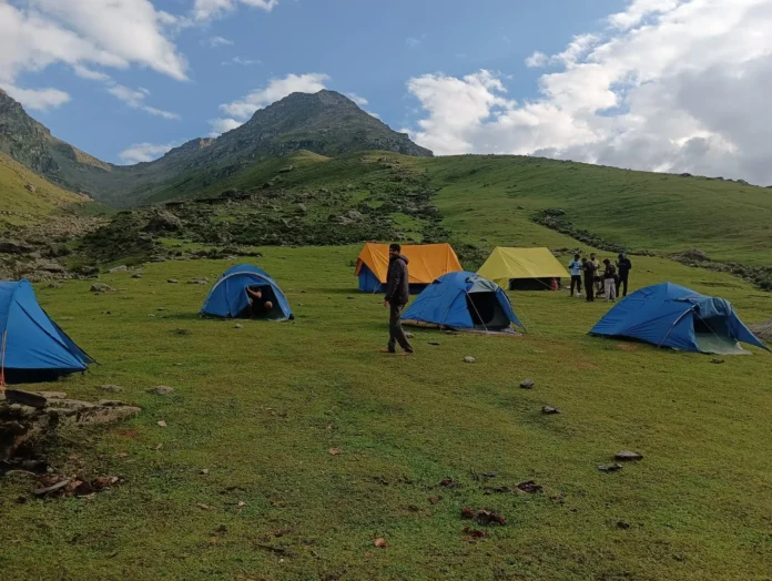
Located in the Kumaon Himalayas in the Munsyari area of Pithoragarh district, the Ranthan Khadak trek begins at Namik village in Bageshwar district and ends at Sarmoli village. It is a route of about 61.5 kilometres, passing through dense forests of pine, rhododendron and oak before reaching vast alpine meadows at an altitude of about 3,900 metres (roughly 12,900 feet). The trek offers scenic views of famous Himalayan peaks such as Nanda Devi, Nanda Kot, Panchachuli, Trishul and Maiktoli. The best time for the trek has been identified as April–June and September–November. This trek is not just a walk through nature but a reflection of a centuries-old relationship between local communities, seasonal livestock grazing and the natural environment. In spring, the route becomes one of the most striking rhododendron corridors in the Himalayas, while in autumn, clear skies reveal golden meadows and snow-covered peaks.
The trek route has been divided into a six-day journey — beginning at Namik village on day one, followed by Thalthok, then Sudamkhan, Puniya Bugyal, Bhaisiya Tal, and finally concluding on day six via Khaliya Top at Sarmoli village. At every halting point, facilities such as a trek information centre, rest camps, drinking-water stations, campsites and homestay areas, rain shelters and rainwater-harvesting tanks have been proposed.
The region is also ecologically rich. It hosts temperate broadleaf forests of rhododendron, Himalayan alder, Himalayan birch, oak and maple, along with conifer forests of spruce and silver fir. The open grasslands of Bajimaniyan Khadak and Ranthan Khadak are abundant with wild orchids, primulas, anemones and medicinal herbs, which become important grazing grounds for livestock in summer. Wildlife species recorded in the area include the Himalayan black bear, red fox, Himalayan musk deer, Himalayan goral, monal and koklass pheasant.
Panwali Kantha Trek: A Historic Path Linking Kedarnath and Gangotri
Located in the Garhwal Himalayas, the Panwali Kantha trek begins at Kalibagi village in Tehri Garhwal and goes to Triyuginarayan in Rudraprayag district. In ancient times, it served as a trade and pilgrimage route between Kedarnath and Gangotri. This roughly 44-kilometre route rises from an altitude of about 2,000 metres to 3,963 metres (13,002 feet), passing through dense oak-rhododendron forests, alpine bugyals, rocky ridgelines and traditional grazing grounds. The route offers scenic views of peaks such as Chaukhamba, Kedar Dome, Neelkanth, Thalay Sagar and Meru. The area experiences a wide range of climatic conditions, from heavy monsoon rain to winter snowfall. Given its remoteness and limited infrastructure, plans are in place to develop sustainable facilities here such as rain shelters, emergency refuge points, information centres and wayfinding systems. The best season for the trek has been identified as May–June and September–November.
This six-day journey begins with a drive from Dehradun to Kalibagi, then continues through Gawanmanda, Dophand, Diuli Top to Panwali Kantha, followed by Kankhaliya Khal — the highest point of the trek at 3,506 metres — to Maggu Chatti, and finally concludes at the Triyuginarayan temple. According to Hindu mythology, Triyuginarayan is the site where Lord Shiva and Goddess Parvati were married, and its eternal flame, burning for centuries, makes it an important pilgrimage site.
The traditional temporary shelters called “channis” along the route, which have long served as resting places for shepherds and their livestock, form an important part of the project. Restoration and signage are proposed for several channis located at Dophand and Panwali Kantha. Vegetation in this area includes oak-rhododendron forests and the alpine meadows of Panwali Bugyal, home to herbs such as primroses, anemones, geraniums and orchids. Wildlife recorded in the region includes the Himalayan black bear, musk deer, bharal (blue sheep) and Himalayan monal.
“Minimal Disturbance, Maximum Sustainability”
The project’s stated vision is to create a resilient trekking corridor that is in harmony with the Himalayan landscape, enhancing the trekking experience through minimal-impact interventions, empowering local communities, and preserving the ecological and cultural identity of Ranthan Khadak and Panwali Kantha.
This vision has been organised around five pillars. First, “Landscape First” — keeping the physical footprint of every construction to a minimum while preserving the ecological integrity of the mountain environment. Second, “Build Lightly and Responsibly” — creating infrastructure from local materials that is easy to maintain and cannot be stolen. Third, “Enhancing the Trekking Journey” — improving access and wayfinding without compromising the character of the wilderness. Fourth, “Community Stewardship” — strengthening livelihoods through sustainable tourism and involving community guides in trail information and cleanliness awareness. Fifth, “Future-Ready Sustainability” — promoting responsible tourism and creating a scalable model for future Himalayan trekking routes.
Four objectives have also been laid out for the project: ecological conservation (minimising damage to the natural terrain and vegetation), contextual development (using local resources such as stone, timber and soil-filled sandbags), trekker experience (creating rain shelters, resting points and viewpoints along the route), and a resilient framework (climate-responsive, low-maintenance and sustainable infrastructure).
Several types of construction have been proposed under the infrastructure plan. The most prominent is the “Trekking Traction Centre” — a vibrant hub for rest, interaction and trail engagement, to be built using climate-responsive, soil-filled sandbags. It will be based on a youth-centric design, featuring open windows, better visual connectivity, and a construction style that is traditional yet contemporary. The report places special emphasis on ensuring the centre does not resemble “a typical government building.”
The second component is rain shelters, which will be built using soil-filled sandbags and local timber. These will be small, low-tech structures that can be built and repaired on site. Each shelter will be able to accommodate around 9–10 people for rest, with sleeping space for 5–6.
The third component involves repair of damaged sections of the trek route, using soil-filled sandbags as retaining walls to create safer, clearly defined paths on slopes.
The fourth component is signage — directional markers that will be installed without foundations, anchored to soil and boulders using metal plates. The design is intended so that the natural weathering of materials over time becomes part of the design language itself.
The fifth, and culturally most significant, component is the restoration of traditional “channis.” These are temporary shelters that local communities have used for centuries, historically serving as resting spaces for shepherds and their livestock. The traditional style of construction is proposed to be revived to suit modern trekking needs. In addition, entry and exit gates are also proposed, to be built using local timber, marking the threshold between settlement and wilderness.
Community Participation and Livelihood Strategy
The project is not limited to physical infrastructure alone; it also includes a detailed operational strategy divided into four parts. The first is the formation of a “Community-Led Trek Management Committee,” in which local stakeholders will jointly manage trekking activities to ensure sustainable tourism, safer trails and shared economic growth.
The second part is a “Revenue Generation Model,” under which sources of income for local communities will be created through trek registration fees, equipment rental, accommodation and guide services, and centres selling local food, souvenirs and products. Registration will be mandatory for every trekker, certified local guides will be appointed, and equipment such as dormitories, tents and sleeping bags will be available for rent at the Trekking Traction Centre. Local woollen products, herbs and handicrafts will also be offered for sale.
The third part is a “Standard Operating Procedure” (SOP), which will lay down guidelines for pre-trek preparation, conduct during the trek, waste management, carrying capacity, and directions for local communities. This includes provisions such as identity verification, a medical fitness declaration, a “carry-in, carry-out” waste policy, seasonal limits on the number of entrants, and the use of reusable water bottles.
The fourth part is “Guide Training and Employment,” aimed at training local youth in trekking, safety and hospitality skills and providing them long-term employment opportunities — improving the visitor experience while also promoting responsible tourism and long-term ecological conservation.
According to Tourism Secretary Dhiraj Garbyal, the Ranthan Khadak and Panwali Kantha treks will not only emerge as new and attractive destinations on Uttarakhand’s tourism map, but will also demonstrate how sustainable tourism infrastructure can be built in mountainous regions with minimal ecological disturbance. He said that the participation of local communities, the revival of traditional construction styles, and a well-planned revenue model together will present this project as a potential model for future trekking development in the Himalayan region.